Monday, April 30, 2018

Slow Moving Trough Bringing Desperately Needed Valley Rain

Over the weekend, I noticed that my lawn and gardens were looking thirsty.  Awfully thirsty.

April is climatologically the wettest month of the year in Salt Lake City.  The long-term average monthly precipitation since 1928 is 2.10".  Through yesterday, the airport reported only 1.19" for the month.  

However, nearly all of that precipitation fell through April 18.  Since then we had only a trace until it started to rain last night.  In addition, it' has been windy and warm.  Saturday in particular featured a record high of 87˚F with dry southerly winds.  

Thankfully, a slow moving cold front delivered desperately needed valley rain last night.  If you look carefully at the radar imagery this morning, you can see the flow shifting from SW to NW across the trough and how the trough is slow moving across northern Utah.  More importantly, there's plenty of valley rain.  


Precipitation totals through about 8 AM include 0.34" at the Salt Lake City International Airport, 0.47" at the University of Utah, 0.69" near the mouth of Mill Creek Canyon, and 0.67" near the mouth of Little Cottonwood Canyon.  Observations from Alta-Collins aren't currently feeding into MesoWest, but alta.com suggests 4" accumulation at 9700 feet as of 7 AM.   

Valley rain and mountain snow will continue this morning and transition to showers this afternoon.  Snow levels are expected to be 5,500-6,500 feet, but we may see snow at times down to bench levels.  

If you are thinking of calling in sick for some powder turns, consider that ski conditions this weekend were best described as "summery."  The snowpack was baked.  You could find a smooth surface in lower angle areas, but many steeper areas were lumpy from sloughs, rollerballs, and the like.  They probably froze into a coral reef overnight.  


Finding a those areas with a smooth underlying surface is going to be key today.  I'll be watching and seeing how things stack up today to see if sneaking out later or early tomorrow might be worth the effort.  

Saturday, April 28, 2018

Summer Skiing

There's little point in calling it spring skiing.  Temperatures are at record levels and running near averages for June 21st.  Nevertheless, Alta looked beautiful and the turns through noon were actually quite good. 


The snow is going fast, however, on all aspects, with the south-facing side of the highway looking pretty bare for April 28th. 


The Snowbird SNOTEL lost 4.4 inches of snowpack water equivalent in the past week, which is about 15% of the snowpack at that location.  I'm sure south aspects did worse. 

More seasonable temperature return tomorrow, thankfully.  It is remarkably dry down here in the valley thanks to warmth and wind.  My grass is getting crispy and brown already. 

Thursday, April 26, 2018

Eyewitness Account: The Tateyama–Kurobe Alpine Route

Guest Blogger: Larry Dunn 

Ever since I started skiing when I was 14 years old, I became a connoisseur of road-side snow banks.  When traveling to a ski area, it was always a good sign when the snow banks were growing higher and higher as you got closer to the resort.   Good snowbanks in the Cottonwood Canyons are those that are about as high as your car when driving up the road, and its always a good sign when the snowpack seems to just spread out away from the road at nearly the same height as the top of the snowbank.  So, some years ago when I first saw pictures of what seemed to be truly amazingly high snowbanks towering over the tops of tour buses in Japan, it got my attention.


Last week while in Japan I got a chance to go indulge my passion for snowbanks while traveling on the Tateyama–Kurobe Alpine Route.  The Alpine Route is basically a one-day transect of the northern Japanese Alps via bus, multiple cable cars, a tram, and two tunnels.  This portion of the Japanese Alps rise from the sea-level plane near the port city of Toyama on the west coast of Japan to around 3000 meters over a very short distance.  The mountains are less than an hours drive from Toyama.

Schematic of the Alpine Route.  Source: https://www.alpen-route.com/en/live_camera/murodo.html.

The Alpine Route Region.  Mt. Tateyama (labeled Mt. Tate) near center.  
We started the route at the cable car station at Tateyama (475m).


This cable car takes you to a bus at the top station (977m).  There were a few patches of snow as we started about a one-hour bus ride up through a beautiful forest of cedar trees.  It wasn’t long before there were snowbanks!


As we ascended the trees got smaller and the snowbanks got bigger and bigger.


Eventually we arrived at Murodo (2450m).  I was in snowbank Heaven!  


Clearing the road is no easy task.  You can read about the process here.  

The Alpine Route opens each year on approximately April 15th.  We were there on April 21st.  This is not a permanent snowfield, it all melts, so if you want to see what is known as the Murodo Snow Corridor in its glory, you need to visit in the spring.  


I’ve seen a lot deep snow in places with glaciers, but I think this extensive snowbank, which in places reached up to 17m (~56 feet) tall, might be a personal best for a place where all the snow melts every season.  The rest of the Alpine Route is very beautiful, but the big snowbank will be my lasting memory of the place.


Tuesday, April 24, 2018

Remarkably Good and Bad Snowpacks at Your Doorstep

We're now deep in April and near the time of maximum upper-elevation snowpack in the interior western United States.  The contrast in snowpack characteristics from north to south through our region could not be more striking.  If we look at SNOTEL stations at elevations at or above 8000 feet, there are many in Nevada, Utah, and southwest Colorado that have already lost their snowcover.  In contrast, to the north, there are some in the Greater Yellowstone area with more than 100 inches.  The maximum is at the Fisher Creek Snotel, which is just north of Cooke City, Montana. 


Snowpack water equivalent tells a pretty similar tale.  There's a total loss of snowcover at many sites in Nevada, Utah, and southwest Colorado.  The snowpack is phat to the north.   Sites above 50 inches of water are Fisher Creek noted previously and Grand Targhee in the Tetons.  Northern Colorado and south-central Wyoming have some decent numbers as well, including the Tower and Medicine Bow Snotels, both at 10,500 feet, with over 40 inches. 


We can also identify stations that are at their all-time lowest and highest snowpack water equivalents in the period of record.  This focuses on sites with at least 20 years of data.  Sites at record low snowpack can be found in the Ruby Mountains of Nevada, the southern Wasatch, the plateaus of southern and central Utah, the southern Wind River Range, and the mountains of southwest Colorado.  In contrast, sites at all-time highs can be found in the Dear Lodge Mountains of southwest Montana, the Absaroka Range of Montana and Wyoming, and the Big Horn Mountains of Wyoming. 


Finally, we can look at the percentile rank for these sites, with 50 indicating that the site is right in the middle of past years, values above 75 indicating that it is in the top 25% of past years, and values less than 25 indicating that it is in the bottom 25% of past years.  The contrast in snowpack as one moves northward couldn't be more striking, especially in the Wyoming and Wind River Ranges where one moves from a snowpack that is near or below median to solidly above median as one moves northward. 


It is not uncommon for the southwest to be dry when the northwest is wet (and vice versa), a pattern sometimes described as a precipitation dipole.  This dipole is in part related to ENSO, with La Nina favoring dry years and El Nino favoring west years in the southwest.  However, the contrast this year is especially abrupt and striking. 

If you are a skier, the dwindling Wasatch snowpack may be a bit depressing, especially as it becomes increasingly snirty this week.  On the other hand, you are not far from a remarkably deep snowpack.  Perhaps you should be thinking about a road trip. 

Saturday, April 21, 2018

Peak Snowpack, Emerging Snirt

Based on the forecasts I'm seeing right now, there's a pretty good chance we're at at the apex of the seasonal upper-elevation snowpack right now.

The latest from the Snowbird SNOTEL shows a snowpack water equivalent of 30.1 inches (green line), which is 71% of median for the date and 70% of the peak median.  Those are close because the average time of peak median snowpack is about right now. 


Forecasts for the next 10 days show loaded dice for warm, dry conditions.  You know, the stuff we can't seem to shake.  There's always hope that a weak system or two can generate something, or that the forecasts are simply wrong, but the 6-10 day outlook is pretty telling. 


Thanks to the dust storm earlier this week, snirt is emerging pretty quickly and was visible in many areas this morning.  The photo below is of Lake Peak in upper White Pine. 


The dust is co-mingled with the melt-freeze crust that developed prior to the Tax Day snowfall. 


Sadly, wind and warmth are quickly laying waste to that snowfall and dust is emerging on the top of the snowpack.  This is the basic problem with dust.  The storms are most prevalent in spring, they put dust near the surface of the snow, and it quickly emerges once the snow starts to melt.  In this instance, most of the dust is from a local source in the Cedar Valley west of Utah Lake, although there may have been some more remote sources, such as the Sevier lake bed, contributing later in the day on Monday. 

Turns?  I'm not sure what to call the conditions above 10,000 feet.  Settled powder if generous.  It didn't ski too bad above that level. 


Our future is quite clear in the photo below.  Look how dark that dust is!  It's going to be really really ugly in a few days. 


My advice: Ski this weekend if you can.  After that, it's going to be Snirty Dancing. 

Friday, April 20, 2018

How I Became a Meteorologist

How (or why) did you become a meteorologist?  It's a question I ask my students on the first day of class each semester.  Many people who are meteorologists have wanted to be one for most of their lives.  Often they can point to a specific weather event, perhaps a tornado, hurricane, or winter storm, as the moment that they decided to go into meteorology.  In some cases, I know multiple people who were motivated to become a meteorologist by the same storm

I was infected early by the weather bug.  My path to meteorology was paved by youthful experiences in the Adirondack Mountains.  The weather in the Adirondacks is usually somewhere between partly and mostly crappy,  and in the late 1970s and 1980s the forecasts were truly terrible.  Whether hiking, backpacking, canoeing, nordic skiing, or alpine skiing, we had to be prepared for anything. 

There are, however, two backpack trips that were essential for sparking my interest in weather.  My father and I used camp or backpack in the Adirondacks every Columbus Day weekend, which is a long weekend in New York State.  In 1981, the trip was especially memorable because it had snowed at upper elevations.  We spent three days in the High Peaks Wilderness and hiked much of the Great Range, one of the most spectacular areas in the Adirondacks.  Our experiences greatly stoked my love of snow and my interest in mountain weather.

Dad and I on the trail.  Heavily clothed in cotton.  We had plastic ponchos too.  It was a different time!
The Great Range from Big Slide Mountain.  Gothics is just left of center, named by Adirondack Guide Orson Phelps for the slides that resemble Gothic architecture.   
Filling water bottles from a local stream.  I don't remember ever filtering or treating water.  It was a different time!


The Great Range and other high peaks from Armstrong Mountain

On the summit of Gothics.  This was my 9th "high" peak, one of 46 Adirondack Peaks thought to be at or above 4,000 feet in early 20th century surveys.

On "belay".  Well not really, but some Adirondack trails have cables and other contraptions to aid in the ascent and descent.
A second trip, which I usually cite as the moment I decided to become a meteorologist, occurred a couple of  years later.  We were on an overnight backpack in the High Peaks when we were caught in a torrential thunderstorm.  We hastily descended to a low pass and pitched our tent, eventually waking the next morning in a pond of water.  It was at that time that I decided that was never going to happen to me again and that I would become a meteorologist. 

A strong desire to understand and predict the weather I encounter in the mountains has been a great source of ideas and motivation for me through my career.  When in the mountains, I still feel like a kid in a candy shop.  So much to observe and understand!  The paths of others in my field may be somewhat different, but passion for weather and the natural world seems to flow through nearly all of our veins. 

Thursday, April 19, 2018

Passage of a Bowling Ball

Interesting forecast situation through Friday night as a closed upper-level low, which rumbles like a bowling ball across the American southwest, moves along the Utah–Arizona border.


If you look at the 3-h NAM precipitation forecasts above (color fill) you can see that northern Utah misses out on the action initially, but does get some after the low enters Colorado thanks to so-called wrap-around precipitation.  In the NAM forecast above, that precipitation primarily affects northeast Utah, especially the Uinta Mountains.  The Wasatch are at the edge of the action and in fact Alta gets no precipitation from the forecast above (but it is right on the edge of it). 

The strong contrast in precipitation probability from west to east across northern Utah is better illustrated by the probability of more than 0.10 inches of precipitation during the 12-hour period ending at 0600 UTC 21 April (0000 MDT Saturday) based on forecasts by the Short Range Ensemble Forecast System (SREF).  Note the sharp gradient from about Antelope Island to the western Uintas.


Indeed, if we downscale those SREF runs to account for local terrain effects, we see large spread at Alta, with members producing anywhere from 0 to 0.7 inches of water.  This would fall mostly as wet snow above 8000 feet, with snow levels possibly flirting with 8500-9000 feet Friday night should precipitation linger.
My take is that thisI is that we may see a few snow showers Friday and Friday night, but accumulations will likely be 1-4 inches.  A skunking is perhaps more likely than a surprise dump.  The latter would require the wrap around to extend further westward than indicated by most of the models I'm looking at this morning. 

After Friday night, the forecast for the weekend looks warm and pleasant.  If we do get a decent dump Friday or Friday night, it will turn to mank quickly on Saturday if it isn't already mank at sunrise. 

Tuesday, April 17, 2018

Tax Day Lake Effect Graupelfest

The tax man cometh and hath taken away your spring.

Following a high of 75˚F yesterday, it makes perfect sense to wake up to a coating of snow this morning.  After all, this is spring in the Intermountain West.


Most of that snow was produced by the passage of the frontal band overnight.  However, early this morning, lake effect got going and trained off into the Salt Lake Valley eventually shifting eastward into my neighborhood, namely the Avenues and University of Utah at around 1340 UTC/0740 MDT.


Most of the precipitation falling from then through 0800 MDT was in the form of graupel, which is basically a small ice pellet formed as supercooled liquid water droplets freeze on contact with ice crystals.  The graupel was relatively warm and cohesive and clung together just enough for demonstrations of the viscoelastic nature of snow.


The ski cognoscenti know that graupel is wonderful to ski on.  I would take a good, prolonged graupel storm over the cold smoke any day of the week.   The first thing that came to mind when the graupel started falling as I walked to the bus was, "I wish I was skiing!"

A couple of additional factoids about graupel.  Because of it's higher density and fall speed, and in some cases large size, it can often penetrate farther below the freezing level than regular snowflakes before melting.  Second, it is one of the ingredients for getting charge separation and thunderstorm development.  I haven't seen any lightning detections so far in this storm, but it happened in our lake-effect event last Friday.

Looking for Ski Crampons

I'm looking for some Dynafit ski crampons.  110 mm or 100 mm width.  If you have a used pair to sell, drop me a note at jim.steenburgh at gmail.com.

Monday, April 16, 2018

Where Today's Dust Is Really Coming From (Not Sevier Lake)

The Wasatch Front has long had episodes of poor air quality related to elevated PM2.5 concentrations during our dreaded wintertime inversions.  We have also seen episodes of elevated and sometimes unhealthy PM2.5 concentrations due to blowing dust.  There are multiple dust sources in southern and western Utah, but this winter, the Cedar Valley west of Utah Lake has been especially productive.

One of our post-docs, Derik Malia, first brought this source region to my attention in December.  In my blog post on December 21, we discuss two major dust plume events that clearly originated from the Cedar Valley on 3 December and 19-20 December.  Below are MODIS imagers of those two events clearly showing the plume extending from the Cedar Valley to the Salt Lake Valley.


Today?  Same story.  The latest MODIS shows the Cedar Valley is the primary source for the dust impacting the Salt Lake valley.  Look at the clear plume that begins just to the west of Utah Lake.


Sadly, media reports, such as the one below in the Deseret News (available in full here), are stating that the dust is coming from the Sevier Lake Bed.

This is also being suggested in the tweet below from the Utah DEQ.

The Sevier Lake Bed can be an important source for dust, but in the MODIS image for this afternoon, that dust is going northward into the West Desert (look closely).  Our dust today, and in the December events, is coming primarily from the Cedar Valley.

These plumes are repeatedly impacting over 1 million people in the Salt Lake County and portions of Utah County.   Dust from these plumes, once deposited on the Wasatch snowpack, result in an accelerated snowmelt due to greater absorption of solar radiation.  

Reducing emissions from the Cedar Valley won't eliminate wind-blown dust events, but it would certainly reduce the frequency, duration, and severity of these episodes in the Salt Lake Valley.

Nearly Another Tax Day Storm

Strong cold fronts and associated mayhem are pretty common in northern Utah around Tax Day.  The all-time classic is the 15 April 2002 Tax Day Storm, which produced the 2nd lowest sea level pressure observed in Utah since record keeping began in 1892, temperature falls of 7˚C in 10 seconds and 19˚C in 2 hours, and wind gusts of more than 60 knots.  Others include the 2015 Tax Day Storm, described by Judy Fahys in this KUER article

We would have another today, if not for an oddity in the calendar.  Chances are you've noticed the nuking southerly flow, and the NWS has wind advisories or warning's up for much of weatern and southern Utah.


The view from my office is starting to look dusty.  What a shame it will be if we put down a layer of brown goo on the wonderful white snow we have right now. 

The culprit in this case is a strong front and surface trough to our west.  These features are forecast by the HRRR to extend across far NW Utah at 2000 UTC (1400 MDT) this afternoon. 


Frontal passage is expected late this afternoon (the HRRR pegs it at around 5 PM MDT for the northern Salt Lake Valley).  Sadly, the surface frontal passage will be a dry one, although precipitation will develop in it's wake tonight.  It's a quick hitter event, but don't be surprised if you wake up to some white stuff on cold surfaces tomorrow depending on the elevation of your home.  As usual, monitor official forecasts. 

Now, getting back to Tax Day, what is so special about it?  Basically, its a noteworthy day in the heart of the peak season for strong cold-frontal passages in the Intermountain West. 

Source: Shafer and Steenburgh (2008)
Today's frontal passage almost qualifies as a Tax Day Storm.  Normally, April 15 is Tax Day, but April 15 fell on a Sunday.  While that should shift Tax Day to today, Washington D.C. observes Emancipation Day on April 16, which pushes Tax Day to April 17, tomorrow.

However, if you want to call this a Tax Day Storm, I'm good with it.

Saturday, April 14, 2018

Mother Nature Takes Pity on Wasatch Skiers

It's been a lousy ski season, but if you've given up on it, you are missing out on some great skiing.

Mother Nature took pity on Wasatch skiers and delivered some great skiing.  Most of the Steenburgh group headed to the Wasatch backcountry on Friday for a Mountain Meteorology field day.  No bad luck on Friday the 13th for us.  Note the smiles.


I woke up this morning with an itch to ski some groomers, which I haven't done in about two months.  Conditions at Alta were really fantastic.  The groomers were highly carveable and I even got some freshies in the Castle shortly after the rope drop.  A few clouds did nothing to spoil the day.  The sun can spoil the snow quickly in April, but before the snow softens, it's wonderful to ski with every aspect well lit, something that does not happen during the winter months.


The forecast "closing day" and the Frank is looking warm and springlike, with some mid and upper-level clouds around and a breeze from the south picking up late during the day.  None of this will deter the debauchery.

The forecast for next week shows quite a roller coaster with a strong front coming in Late Monday/Monday night and another system advertised for the latter half of the week.  Right now, neither of these looks like it will produce a huge dump, but things can change.  Please Mother Nature, continue the pity party.

Thursday, April 12, 2018

My Cup Runneth Over

It has been a long cool season characterized by frequent doldrums, but today my cup runneth over.

Let's talk first about what happened overnight and some of the complexities of cyclone and frontal evolution over the Intermountain West.

With an approaching trough from the west, one often sees a trough develop over the Intermountain West, typically along an axis running from the high Sierra northeastward across northern Utah.  That was the case last night, which featured a very well developed Intermountain Cyclone, as well as a Pacific cold front that was distinct from this feature and pushed across northern Nevada. 

As can be seen in the HRRR-derived analysis below, the Intermountain cyclone progressed northeastward across northern Utah overnight, with the cold front penetrating into the state and eventually overtaking the concomitant trough. 


This resulted in some strange time series in which the wind shifted to northwesterly before the arrival of the cold front.  For example, at Badger Island along the west shore of the Great Salt Lake, the flow shifted from ENE to NNW around 0900 UTC as the low center tracked to just to it's south. However, this was not the surface cold front, which arrived shortly after 1000 UTC, which snapped the wind sharply to NW and was followed by an increase in wind speeds that eventually reached over 35 mph with gusts to near 50. 


This highlights the importance of using the "forecast funnel" and the need to understand what is happening on the larger scales before trying to understand what is happening locally.  

Another issue this morning is that the precipitation dynamics are not favoring anything that looks like the classical cold-frontal precipitation structures that you see in elementary textbooks and most of which are derived from the Norwegian Cyclone Model, which is nearly 100 years old (cold front at left). 

Source: Bjerknes and Solberg (1922)
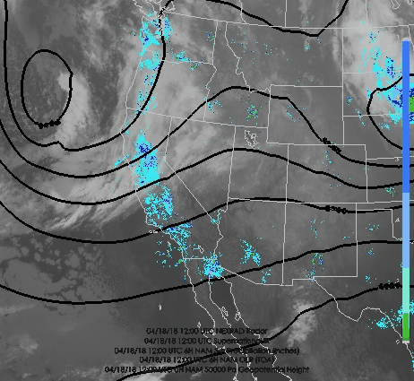
The Norwegian Cyclone Model was a great advance, but there can be large deviations from that model as far as precipitation is concerned.  Note today how disjointed the precipitation is from the cold front (1300 UTC/0700 MDT analysis and radar below).  This is because the cold-front is shallow at it's leading edge and the pre-frontal airmass is dry, so that the strong ascent at the leading nose is unable to generate precipitation.  Instead, precipitation lags the front and is a result of several factors, including the presence of deeper pacific moisture and forcing associated with the upper-level trough.  


The radar loop below shows how things have filled in nicely along the northern and central Wasatch Front through 1405 UTC (0805 MDT).  At that time, a sharp contrast in weather existed from northern to southwest Salt Lake County, with the latter still dry due to the position of the precipitation and some shadowing by the Oquirrhs. 


Similarly, at this time, it was not only dry in Park City, but you could see shadows from the sun!

Source: UDOT
The models are advertising the frontal precipitation to move through today, with the event becoming a more "orographic" one later today, with precipitation generated by forced ascent as the northwesterly flow encounters the Wasatch Range.  Temperatures will also be dropping, so rain will be turning to snow on campus this morning (it's mixing in as I write this at 0830 MDT).


The latest weather summary from the NWS is provided below.  Get updated forecasts at https://www.weather.gov/slc/.

Source: NWS
For the mountains, this is still looking like a pretty good spring storm.  The time-height section for Salt Lake City shows the frontal passage this morning, and then periods of moist, unstable, NW flow through tomorrow morning.  

The latest NWS forecast for the upper Cottonwoods is below and tells the tale fairly well.  

Source: NWS
The post-frontal stuff later today and tonight is always a bit of a crapshoot.  Right now, it looks pretty good and I'd say the odds of deep powder tomorrow are high.  If you are skiing later today be aware that there is a chance of thunderstorms and keep and eye to the sky.  Tomorrow, the quality of skiing may be somewhat dependent on winds as the models are advertising fairly strong 700-mb flow through the period.