
Let us begin at the Salt Lake International Airport where there are relatively long weather records. Total precipitation (liquid equivalent) since 1 November is 3.00 inches, well below the 1981–2010 average for the period of 5.81 inches. However, during that period, the airport actually received 39.9 inches of snow, which is not far behind the 1981-2010 average of 45.6 inches. Snowfall at one location, by itself, tells a pretty incomplete story.
It tells an incomplete story because the period from 1 November to 12 March is also the warmest on record, with a mean temperature of 39.9˚F. Only three previous periods come close: 1933/34 (39.6˚F), 1977/78 (39.5˚F), and 2014/15 (39.4ºF).
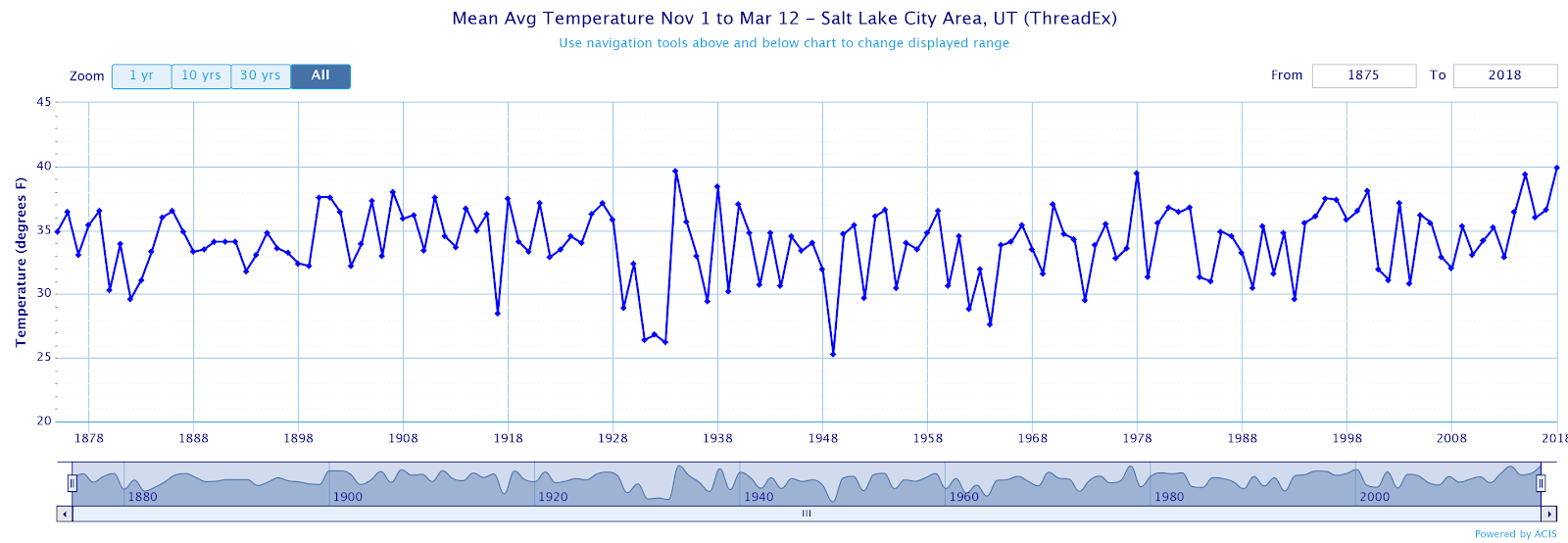 |
| Source: NOAA Regional Climate Centers |
In the mountains, SNOTEL data records only go back to 1979 to around 1990 for most stations in and around Utah. Nevertheless, if we look at the current snowpack water equivalent, many sites in Utah are at their lowest levels on record for this date. Nearly all sites, with the exception of a few on the north slope of the Uintas and in the far northern mountains, are in the lowest 25%.
 |
| Source: NWS |
Thus, in the mountains, this has been a very poor snow year. However, the causes of that poor snowpack vary with location, aspect, and elevation. Let us focus initially on the influence of elevation by looking at SNOTEL observations from Ben Lomond Peak (7689 ft), a relatively sheltered mid-elevation site, and Ben Lomond Trail (5972 ft), a relatively sheltered low-elevation site. This is one of the few places where SNOTEL stations are located at two sites along a fairly direct elevation transect, enabling one to highlight how the snow climate of a given winter varies with altitude.
At Ben Lomond Peak, 17.4" of precipitation (liquid equivalent) has fallen since October 1st. Remarkably, 82% of that precipitation is retained in the snowpack, which has a water equivalent of 14.3". Thus, the warmth of this winter has had at most a small impact on the snowpack at this site. The lack of snowpack here is due primarily to the lack of precipitation. If one were to go to even higher elevation (e.g., Snowbird snotel at 9617 ft), nearly all of the precipitation since October 1 is still retained in the snowpack.
 |
| Source: NRCS |
In contrast, at Ben Lomond Trail, 17.1" of precipitation (liquid equivalent) has fallen since October 1st, but only 27% of that precipitation is retained in the snowpack, which has a water equivalent of 4.6". That is a remarkably low number. On average, this site would retain about 70-75% of the precipitation since October 1st in the snowpack on March 13th.
 |
| Source: NRCS |
Thus, the low snowpack at Ben Lomond Trail is due to both a lack of precipitation and warmth. The latter reduces snowpack water equivalent by causing a greater fraction of wintertime precipitation to fall as rain instead of snow and more frequent or severe snowpack ablation events. Ablation is the loss of snow to melt and sublimation.
Records at Ben Lomond Trail go back to 1981, enabling one to put this season into a nearly 40-year context. As shown by the bottom green line below, during that period of record, this is the worst snow season. Since early February, the site recorded its lowest snowpack water equivalents on record. The next lowest season on March 13 is 2014/15. Note the drop in snowpack water equivalent due to warmth in early February.
 |
| Source: NWS |
An important lesson from this analysis is that the vulnerability of snowfall and snowpack to warming in Utah is strongly dependent on elevation. The lower elevations are far more vulnerable than the upper elevations. On the other hand, because SNOTEL stations are located in relatively sheltered and typically shady location, we don't have a good handle on how things vary at a given elevation with aspect. South aspects are likely more vulnerable to mid-season ablation events, but how much is unclear. That vulnerability might also vary due to factors such as dust deposition onto the snow. Perhaps those in the snow hydrology business can comment.
If I were to speculate further, here are a few expectations for what will happen in northern Utah as we move through the 21st century in a warming world:
- Year-to-year variations in temperature and snowfall will still play an important role. In the near future, there will be some good snowfall years and some bad snowfall years, but eventually, global warming will have an increasingly caustic effect on our snow climate (it already is). The dice are loading for warmer winters. Low elevations are going to suffer the most.
- As far as Utah ski resorts are concerned, Alta and Snowbird sit in the catbird seat. They have altitude and aspect on their side. Bad snow years at those altitudes are still driven primarily by low precipitation. Snow that falls on their north facing slopes tends to stick around for most of the season. They have some vulnerable areas (e.g., portions of Mineral Basin, areas around the High Traverse), but overall they have it good compared to everyone else.
- The lower slopes of PCMR, Snowbasin, and Deer Valley are going to become increasingly dependent on man-made snow for operations, as evinced this season. Technological upgrades will probably be needed to increase the likelihood of operations in the early and late seasons in the coming decades.
- Global warming will further amplify pressure for mid-winter recreation in the upper-elevation terrain around the Cottonwood Canyons. One can see this already happening. I have historically ski toured in other areas of the Wasatch and nearby ranges during busy weekends, but this has been very difficult this year. There simply isn't the snow.
Sadly, change is coming. On the plus side, I don't think that this year is the new normal. It represents what we can get in a warming world when natural variability favors a warm, dry period. It does, however, provide an illustration of how vulnerability varies with location, elevation, and aspect over northern Utah.
would it be accurate to say last seasons climate and this years are just as common? Maybe moving into a world of more intense extremes?
ReplyDelete